https://pixabay.com/photos/tianjin-sunset-city-aerial-view-2185510/
The Urban Heat Island effect is a micro-climatic phenomenon that involves the warming of urban areas mainly due to the large-scale modification of land use, which will affect more than ½ of the global population who live in urban areas (soon to be 70% by 2050 according to the UN) and creating a difference in the average temperature between urban and rural areas.
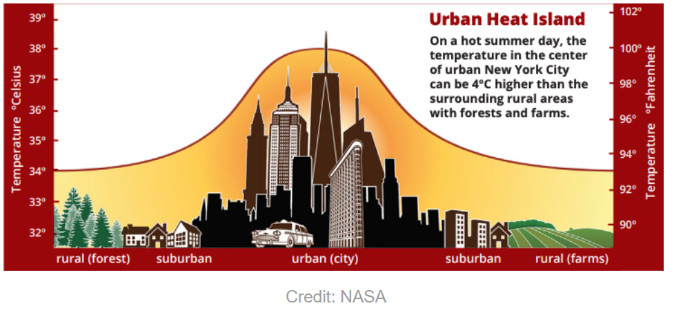
The urban heat island effect is characterised by two types of heat islands: surface and atmosphere. Surface heat islands occur when man made surfaces such as roads and buildings absorb and retain more solar heat than natural landscapes, resulting in higher ground-level temperatures within cities. In contrast, atmospheric heat islands form when areas create their own microclimates, trapping warm air above the city due to limited evaporative cooling and the buildup of pollutants. Both types have different effects on the urban environment: surface heat islands directly affect ground temperatures, while atmospheric heat islands influence air quality and atmospheric dynamics. While the UHI effect contributes very little to global climate change, effects of the enhanced greenhouse effect and urbanisation such as air pollution, energy demands and adverse health effects are likely to worsen to a large extent within cities. By implementing urban planning and design strategies, cities can not only mitigate heat absorption but also promote sustainability and improved quality of life for urban residents.
The physics behind the urban heat island effect revolves around changes in surface properties (albedo, heat capacity), alterations in natural processes (evapotranspiration), and the increase in anthropogenic heat sources.
In an urban setting, the energy balance equation can be represented as:
Q∗ + QF = QH + QE + QS
Net All-Wave Radiation (Q*): This includes both incoming shortwave radiation from the sun and outgoing longwave radiation from the Earth's surface. In urban areas, the balance is typically positive during the day as surfaces absorb solar energy.
Turbulent Latent Heat Flux Density (QE): Latent heat is associated with water processes, particularly evaporation and transpiration. Urban areas often have less vegetation and open water bodies, reducing QE. As a result, there is less energy being used to convert liquid water to vapour, leading to less cooling through evaporation.
Turbulent Sensible Heat Flux Density (QH): Sensible heat is the heat transferred between the surface and the air, causing a change in temperature. Urban materials often have high thermal conductivity and heat capacity, which means they store and release large amounts of heat, increasing QH. This flux is responsible for the direct warming of the air in contact with urban surfaces.
Net Heat Storage (QS): Urban materials like asphalt and concrete have high specific heat capacities, meaning they can store a lot of thermal energy. During the day, these materials absorb and store heat, which is gradually released during the night, maintaining higher temperatures even after sunset. The heat storage capacity is a crucial factor in the UHI effect.
Heat Release by Combustion (Qf): This is the heat generated from human activities, including vehicles, industrial processes, and heating/cooling systems. Unlike natural landscapes, urban areas have high Qf, which directly adds to the total energy in the system. This is depicted in the diagram below as originating from sources within the urban canopy layer.
The combination of these factors leads to a positive net heat gain in urban areas, exacerbating the UHI effect. The canopy layer traps heat within the urban environment, reducing the potential for cooling at night, while the boundary layer interactions affect the extent of heat dispersion into the upper atmosphere
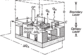
- Oke, 1988 The urban energy balance Figure 1B
- Modified from Oke, 1982, and Runnalls and Oke, 2000
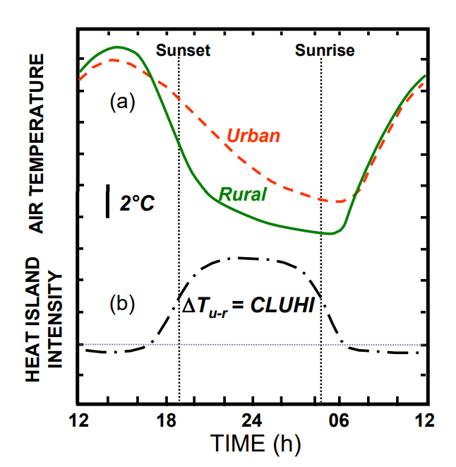
Δ Tu-r = Tu − Tr
Tu-r - UHI intensity
Tu - urban temperature
Tr - rural temperature
CLUHI - CLUHI stands for Canopy Layer Urban Heat Island Intensity, the difference in urban and rural air temperature that occurs from the ground to the roof of urban buildings.
The graph above highlights the UHI effect, demonstrating that urbanisation leads to higher temperatures which are more noticeable during the evening and night. This effect can have implications for energy consumption (e.g. increased air conditioning use), public health (e.g., heat stress), and local climate patterns.
The upper section (a) shows the diurnal air temperature variation, with the urban temperature (red dashed line) consistently higher than the rural temperature (green solid line). The lower section (b) illustrates the Canopy Layer Urban Heat Island Intensity (CLUHI), defined as the temperature difference (Tu-r) between urban and rural areas. During the daytime, urban temperatures rise more rapidly and reach higher peaks due to the absorption and retention of solar radiation by buildings, roads, and other structures, which have high thermal masses and low albedos. These materials absorb more solar energy and release it slowly, leading to elevated temperatures. Conversely, rural areas, characterised by vegetation and open land, reflect more sunlight and cool more efficiently through processes such as evapotranspiration, resulting in lower temperatures.
At night, the temperature difference between urban and rural areas increases, as shown by the peak in CLUHI around midnight. Urban structures release stored heat slowly, maintaining higher temperatures, while rural areas cool down rapidly due to the lack of heat-retentive materials and more effective radiative cooling to the clear sky. Urban areas have more vertical surfaces, and this means that radiation will tend to be reflected off many surfaces, each one absorbing some of the energy and warming up in the process.. The fact that these tall buildings are so close to each other reduces the sky-view factor, meaning the view of the sky is obstructed by buildings, limiting the escape of long-wave radiation and trapping heat. This effect is amplified by multiple reflections and re-absorption of radiation within urban canyons, further increasing nighttime temperatures.
The usage of cars in cities can lead to the emission of hygroscopic pollutants acting as condensation nuclei - trapping radiation by creating a pollution dome - exacerbating the UHI effect. These particles, which include sulphates, nitrates, and organic compounds, can absorb water vapour from the atmosphere, altering cloud formation processes and contributing to the formation of secondary aerosols. In urban environments, these aerosols act as cloud condensation nuclei (CCN), influencing cloud properties such as droplet size, which can lead to changes in local precipitation patterns and cloud cover - urban areas have greater cloud cover of around 5%–10% more than rural areas. Also, hygroscopic particles can indirectly intensify the UHI effect by enhancing the absorption and scattering of solar radiation, reducing surface albedo, and trapping heat within urban areas. As a result, pollution domes experience higher temperatures compared to surrounding rural areas, exacerbating increasing energy demands for cooling to a large extent.
Pollution domes can also reduce the heat island effect through the filtering of insolation that reduces the range between daylight and nighttime temperatures. Ultimately within population domes, the effects of the fine particulate matter on the reduction of evapotranspiration, and trapping heat in the local enhanced greenhouse effect exacerbate impacts of the UHI effect more than reducing it.
- factsheet 14 microclimates [Met Office] Figure 17, Figure 18
In the first diagram, the pollution dome forms due to the increased thermal energy generated in urban areas. Cities, with their dense infrastructure, have a high thermal capacity and low albedo, meaning they absorb and retain more solar energy. This absorbed heat is subsequently released, warming the air above the city and creating a layer of warm air that rises. Due to thermal inversion, where a layer of cooler air overlays the warmer urban air, the warm air gets trapped beneath this cooler layer because the cooler air is denser and acts as a lid, preventing the warm air and its pollutants from dispersing vertically. The trapped warm air forms a dome of pollution over the city, as illustrated, leading to high concentrations of pollutants at ground level. Pollution domes allow short-wave insolation to enter but also traps outgoing terrestrial radiation as this has a longer wave-length
In the second scenario, the urban heat island effect once again generates a localised area of warmer air with pollutants. However, the prevailing wind, moving from one direction, exerts a horizontal force on this warm air mass. The interaction between the warm air and the horizontal wind forces results in the advection of the polluted air away from the city. This process forms a pollution plume that extends into surrounding areas, emphasising the broader impact on atmospheric conditions and air quality.
Albedo & Infrastructure
Albedo represents the reflectivity of a surface, with values ranging from 0 (no reflection) to 1 (total reflection), while emissivity indicates the ability of a surface to emit thermal radiation, with values close to 1 representing efficient emitters. For instance, roads typically have low albedo values (0.05-0.20) [1] and high emissivity (0.95), meaning they absorb most of the solar radiation and emit heat efficiently. Similarly, common building materials like concrete and brick have low albedo values (0.10-0.35) and high emissivity (0.85-0.93), contributing largely to the absorption and re-emission of heat in urban environments. These properties collectively exacerbate the urban heat island effect, where urban areas become significantly warmer than their rural surroundings due to the extensive use of low-albedo, high-emissivity materials.
The existence of the urban heat island has a number of socioeconomic impacts. Urban populations find the added urban warmth to be stressful if the city is located in an already warm climate. From an economic standpoint the heat island is beneficial in reducing the need for winter space heating, but disadvantageous in increasing the demands on air-conditioning. Mitigating the urban heat island effect can involve increasing the albedo of urban surfaces to reflect more sunlight and thus absorb less heat. For example, using reflective materials for roads and roofs, such as white paint or lighter-coloured tiles, can substantially increase albedo (e.g. white paint has an albedo of 0.50-0.90). This can reduce the overall heat absorbed by urban infrastructure. Furthermore, incorporating materials with lower emissivity values where appropriate can help manage heat retention and re-emission.
Due to systemic inequalities and historical segregation, certain low income and minority communities can be at more risk from the UHI effect. An example is in Los Angeles, where Latinos make up 50% of the city’s population, but make up 67% of the population in communities with high vulnerability to extreme heat [2]. Therefore there are higher health risks during heatwaves, including heat exhaustion, heatstroke as well as an overall lower quality of life in these enclaves. To counter this, solar-reflective materials were used to reduce heat retention in these neighbourhoods. While authorities only seek to protect 1500 blocks currently ( 2% of the approximately 70,000 city blocks in Los Angeles), other city blocks are much more well-off and are able to cope with the heat island effect. A year after the covering of cool pavement in Pacoima (a low-income, multicultural, working-class community ), the local temperature had reduced by 3.5℃, suggesting that the mitigation strategy was largely successful, which will not only reduce the heat island effect but also effects of spatial inequality.
In addition, water bodies being incorporated into urban spaces play an important role in regulating temperature - reducing heat retention in their surroundings. Its high specific heat capacity enables it to absorb large amounts of heat with minimal temperature change. Water bodies also influence local microclimates by generating breezes and increasing humidity levels through rapid evaporation which can create "oasis effects" in water bodies and helps cool the surrounding surface air, counteracting the existing UHI effect. The Los Angeles River revitalization project aims to improve stormwater management through the creation of bioswales and permeable pavements, which not only mitigate flooding but also allow groundwater recharge. As water percolates through the soil and reaches the groundwater table, it helps to cool the surrounding area through evapotranspiration processes, enhancing the local microclimate.
Urban Geometry
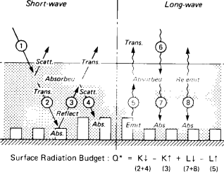
- Oke, 1988 The urban energy balance Figure 1A
The surface radiation budget is represented by the equation in the above, which balances the incoming and outgoing radiation. K↓ represents the incoming short-wave radiation from the sun (denoted by arrow 1), which is the primary source of energy. Some of this radiation is reflected back into the atmosphere, denoted as K↑ (arrow 3). The remaining absorbed radiation contributes to heating the surface. The long-wave components, L↓ and L↑, represent the incoming and outgoing long-wave radiation, respectively. Urban structures absorb long-wave radiation from the atmosphere (including re-emitted heat from greenhouse gases) and re-emit it. This re-emission is partially absorbed by other urban surfaces, trapping heat within the urban canopy layer. This process is amplified by the geometry of urban environments, where multiple reflections and absorptions occur between buildings and other structures.
In the long-wave spectrum, the absorbed heat is re-emitted as long-wave radiation (6). However, this process is complex in urban environments due to the presence of numerous surfaces that can both absorb and emit long-wave radiation (7 and 8). These surfaces, including buildings, trap heat within the urban canopy layer, reducing the overall cooling rate at night. This trapping effect, combined with the continuous emission of heat from anthropogenic sources, results in a net increase in retained heat within urban areas, exacerbating the urban heat island effect.
- Oke, 1988 Boundary Layer Climates Figure 7.2
In figure (a), the horizontal surface directly receives and reflects incoming shortwave radiation, with an angle of incidence (θ). On convoluted surfaces, the angle of incidence changes due to the surface variations, leading to differential heating and shading effects. These variations cause some areas to receive more direct radiation, while others, particularly in the shaded areas receive less. This can lead to localised hotspots and cooler areas within the same surface, influencing the overall radiation budget by creating microclimates.
In terms of reflection, as shown in figure (b), horizontal surfaces reflect radiation uniformly, while convoluted surfaces scatter reflected radiation in various directions. This scattering can reduce the net radiation reflected back into the atmosphere and increase the absorption by the surface. The emission of long-wave radiation, depicted in figure (c), varies significantly between horizontal (SVF = 1.0) and convoluted surfaces (SVF < 1). A lower SVF in an urban canyon implies that less long-wave radiation escapes to the atmosphere, trapping more heat. High velocities of winds can be created due to the venturi effect, where urban canyons consisting of straight streets lined with tall buildings can funnel winds down, which increases as the buildings rise towards the centre.
Implementing urban planning strategies that prioritise compact, mixed-use developments and maximising natural ventilation can reduce heat buildup compared to sprawling layouts. Designed by Foster and Partners, Masdar City, an urban community in Abu Dhabi, has a compact layout with narrow, shaded streets and high-rise buildings, minimising the Sky View Factor (SVF), allowing for efficient cooling by limiting the emission of long-wave radiation to the sky. This design mirrors the convoluted surfaces in the diagram above, which trap less heat during the night, which has been effective in reducing temperature differences between inner and outer city areas (with the city being up to 5-10℃ cooler than surrounding areas). The city buildings and streets are oriented towards the southeast-northwest axis to provide shading though the day, and minimising thermal gain on the buildings. Around 60% of buildings in Masdar City are covered in opaque walls, unlike glass used in many other cities. Furthermore, the windows are designed to receive maximum sunlight, but the glass is extra thick to prevent heat transfer.
Siemens' regional headquarters in the city serves as an illustration of how to reduce heat retention in buildings; the project was certified LEED Platinum, making it one of the most environmentally friendly workplaces in the Middle East. The funnel-shaped plaza beneath the headquarters uses no energy and uses the venturi effect to remove hot air from the surrounding area. To further decrease heat gains inside the offices, a reflective coating was applied to the aluminium fins to reduce absorption. Additionally, the building's façades behind the shade are airtight and substantially insulated. Siemens estimates that power and water savings will be closer to the designers' forecast of 50% less than a typical Abu Dhabi office building, even when it is completely filled.
However, the city has been criticised as the aspirations of a “zero-carbon city” have led to challenges filling the empty city with general infrastructure for the 50,000 residents who were expected to live there and the 40,000 commuters. In 2023, roughly 15,000 people lived and worked there (5,000 of those were residents), and the community covered less than ⅙ of the area it was intended to cover. While there has been slow progress in developing the city character, ultimately authorities have done significantly well to a large extent in reducing heat absorption which is evident from the recycled low carbon emitting materials, shading and orientation strategies that were used. But the 22 billion dollars the project is originally funded from revenues from oil and gas exports - so there is the question of how the city can be considered sustainable in the first place.
Conclusion
In conclusion, urban planning and design play a crucial role in mitigating urban heat islands by reducing heat absorption, enhancing natural cooling processes, and improving overall urban microclimates. Through strategies such as green roofs, cool pavements, urban greenery, and compact urban design, cities can achieve significant reductions in urban temperatures and create more sustainable and livable urban environments. Real-world examples, such as Masdar City's innovative urban design and Los Angeles' efforts to introduce cool pavements, demonstrate the potential for significant temperature reductions and improved quality of life, as well as mitigating the disproportionate impacts of urban heat on disadvantaged populations to a large extent.
Notes & References
[1] Based on mid-latitude cities in snow-free conditions.
Sources: Threlkeld (1962), Sellers (1965), van Straaten (1967), Oke (1974), Arnfield (1982).
[2]LA County Climate Vulnerability Assessment. (2021). Available at: https://ceo.lacounty.gov/wp-content/uploads/2021/10/LA-County-Climate-Vulnerability-Assessment-1.pdf.
Barry, R.G. and Chorley, R.J. (2010). Atmosphere, weather, and climate. London: Routledge.
Florida, R. (2016). New urban crisis. Basic Books.
Financial Times (n.d.). Masdar City: The eco-oasis blueprint for sustainable cities. [online] pwc.ft.com. Available at: https://pwc.ft.com/article/masdar-city-eco-oasis-blueprint.
Heat Vulnerability in Los Angeles County Resource and Methodology Assessment. (n.d.). Available at: https://crcl.columbia.edu/sites/default/files/content/Southern%20California/LA%20County_Heat_report_200617_compressed.pdf.
Met Office (2019). National Meteorological Library and Archive Fact sheet 14 -Microclimates.
Musco, F. (2016). Counteracting Urban Heat Island Effects in a Global Climate Change Scenario. Cham Springer International Publishing.
Oke, T.R. (2015). Boundary layer climates. Routledge.
Oke, T.R. (1988). The Urban Energy Balance. Routledge.
Omar, W. and Fouad (2018). ZERO CARBON CITY-MASDAR CITY CRITICAL ANALYSIS ZERO CARBON CITY-MASDAR CITY CRITICAL ANALYSIS Recommended Citation Recommended Citation. BAU Journal -Health and Wellbeing BAU Journal -Health and Wellbeing of Fine Arts, [online] 1. Available at: https://core.ac.uk/download/pdf/336856156.pdf.
Comments
Post a Comment